Happy healthy Spring! We hope you have read our Spring Update and now it’s time for more fun.
In researching the origins and location of the Old Military Road, there is no end to the discoveries we make. One such discovery is this delightful essay in the San Juan Islands Almanac from 1981 detailing Marjorie Walker’s attempts (with her friend Mitzi Lowell) to locate the routes of the Old Military Road. And notice I say routes, as there were several which you can see in her Map below. Also fun to see is the route of a telegraph line that was installed too late to help the commanders of British and American Camps. Here again the Old Military Road provided the fastest means of communication between the two nations.
Marjorie Walker (1906-1992) was a renown and unconventional artist and teacher who lived on False Bay Road for 40 years. You might remember she was the subject of Friday Harbor’s Sunshine Alley Project several years ago. We hope you enjoyed that, but if you’ve not seen it yet, it is worth a look to learn more about her and also some OMRT history of that time. It has been on those display panels in Sunshine Alley (right next to the Palace Theater on Spring Street) since May 2023.
Another connection we have with Marjorie is that False Bay Road is on our OMRT route as we swing off the main Old Military Road to take in the False Bay Ecological Preserve and beautiful historic farms. This scenic bypass is a fine example of how our route will rely on quiet roads, and enlarged public shoulders along busier roads when it can’t actually be on trails on public lands or voluntary easements on private property.
Best wishes on your own explorations. It’s Spring so get out and enjoy our island’s many gorgeous trails. We appreciate your support!
The Old Military Road Trail Team
And now, here’s Marjorie’s essay from the San Juan Island Almanac:
Finding the Old Military Road
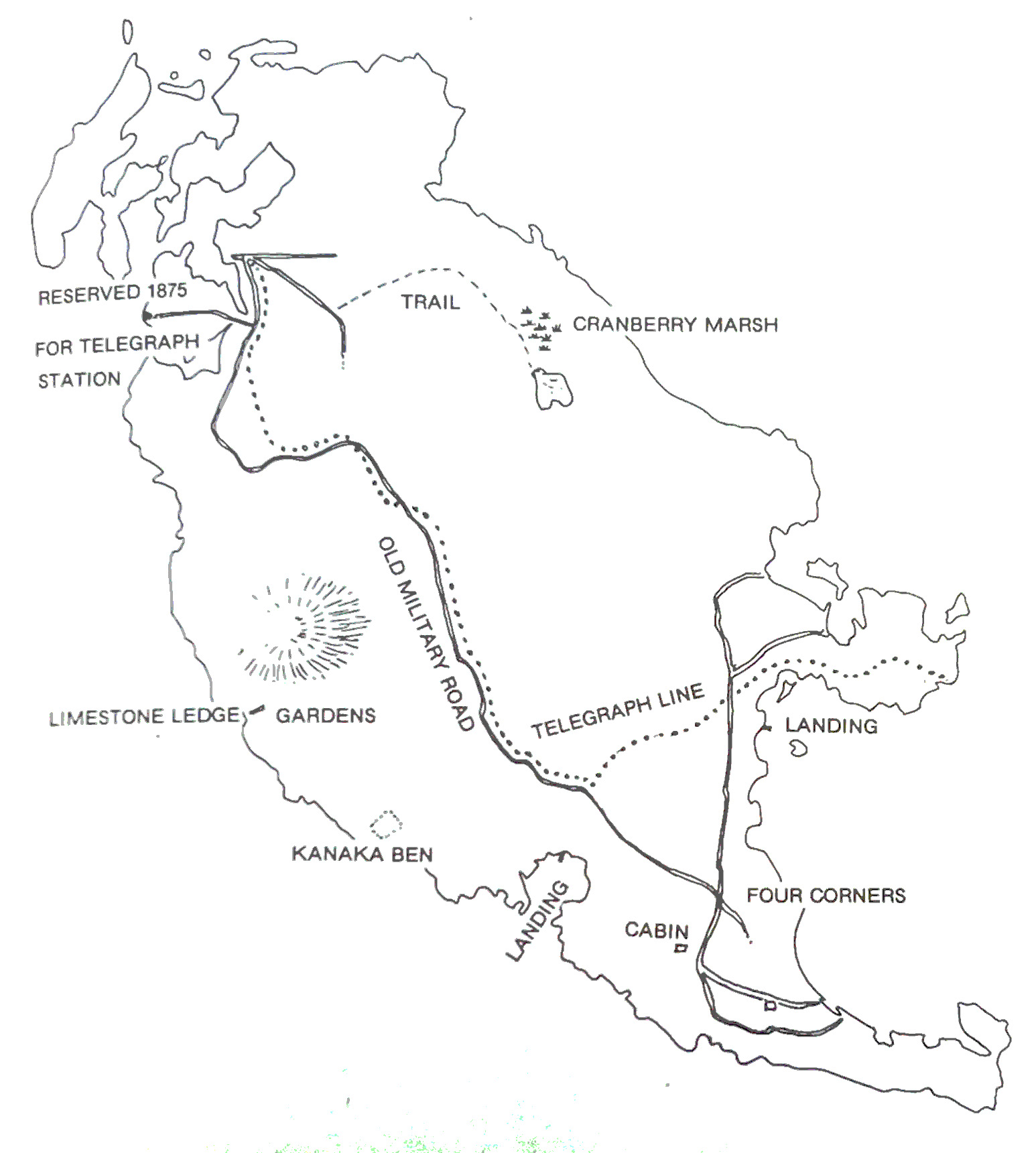
Information based on map from 1875 – Courtesy Marjorie Walker
During the years of the Pig War, wagon wheels rolled over a road running practically the length of San Juan Island connecting English and American Camps. The wagons using this road brought together the soldiers on opposing sides for socializing. The old Military Road, built in 1860, is now almost obliterated, but signs of its existence are there if you are willing to look closely.
For those whose memories need refreshing, the Pig War was caused by disagreement over the boundary line between Canada and the United States. In the middle of the boundary dispute lay the San Juan Islands. In 1859, American and British troops set up opposing camps on San Juan Island after an American homesteader shot a British pig. This was the only casualty of the war and the troops actually met quite often and were friendly during their stay on the island. The boundary was determined by the arbitration of the German Kaiser Wilhelm I in 1872 and the islands became American.
Marjorie Walker of San Juan Island spent several years studying the exact location of the Military Road and now probably knows more about where the road was than anyone else. She and Mitzi Lowell, who died just recently, compared old maps and surveyor’s notes to the terrain, measuring with Marjorie’s 100 foot tape measure from landmarks mentioned on the map to places where they could see signs of a well-traveled road. “I just did it for fun, and there are those who don’t agree with me as to the exact location of the road,” Marjorie says. But she is pretty sure about her “working map.”
Using primarily an 1875 road map that she found buried in the archives of the County Road Department, Marjorie found that the road began at English Camp and traveled up the side of Cady Mountain. Cady Mountain, her map shows, was originally called Keddy Mountain after the Keddy family who lived there.
Besides the beginning of the Military Road, there were two other roads starting at English Camp: one to Mt. Young, and one to Three Corner Lake. There was also a trail to Sportsman’s Lake and a telegraph line that followed the road for a time and then veered off to Bald Hill (where the gravel pit is now) and out to Pear Point.
After the road left Cady Mountain it crossed the present Beaverton Valley Road east of Boyce Road and then crossed San Juan Valley through what is now Zylstra Lake. From the valley, it crossed the False Bay Road and went up the steep terrain to what is now Portland Fair. When she got to Portland Fair, Marjorie wondered why it was named that and began digging for some earlier names of the area. “I figured out that it was probably called Port l’Anterre or Port l’Angleterre which would mean Port to the English and would mark the beginning of the road. That’s the only explanation of the name Portland Fair that I could come up with and I think it’s pretty clever.”
She also found the first school house on the island just off the present Portland Fair Road and on the old military road route.
“Some people will argue with me about that location but I’m convinced it’s right. Of course, the real first school was in a kitchen at Cattle Point.” The school is dated 1867 on the old map. Marjorie also noticed a 7 mile post indicated on the map near Portland Fair and so again measured the distance indicated on the map and found a mound of brush holding up a portion of a stake she believes to be the old 7-mile post.
From Portland Fair the road crossed what’s now the Cattle Point Road and continued east until it met the old road to Argyle at a place called Four Corners. There were marks on some rocks there that puzzled Marjorie until Adeline Throne, one of the Rosler family, (Rosler was an American soldier who stayed on to farm on the American Camp property), told her the marks were made by wagons traveling on the old road. She also found in several places that the bark on trees was nicked, probably by the wagons. “Aerial photos were a big help too because you can see the opening in the trees where the road went,” Marjorie says.
At another spot along the road, she found some ancient charred wood where the map showed an old tavern that was said to have burned to the ground. She has also found the remains of two bridges on the road, one where the creek that empties into False Bay crossed the road, and one where the False Bay Road is now located.
After the road left Four Corners, it swung down to the water side of the present Cattle Point Road just before the entrance to American Camp.
The road then ran south of the redoubt at American Camp and turned down to what was Old Town on Griffin Bay.
The Military Road was gradually abandoned when new roads were built on the island and its route now runs through private property. But the wagon wheel marks and other signs of military life along the road keep alive the spirit of a way of life for the friendly enemies of the island’s past who visited each other via the road to play a game of cards or swap yarns around the burning fire while sipping a mug of English or ‘San Juan’ brew!