Proposed Route
The Route of the Old Military Road Trail
The 21st century route to honor the Old Military Road Trail has not been completely defined. The OMRT route, at least in part, will be created after an extensive public planning process.
The proposed route will be determined realistically by only using property already open to the public, by permission of private landowners who will welcome the trail on their land and by the use of public roads.
The original 1850s route was modified as decades passed and the San Juan Island population grew. The new trail will in some places cross or follow closely the original Old Military Road but for the most part will match our current times and circumstances.
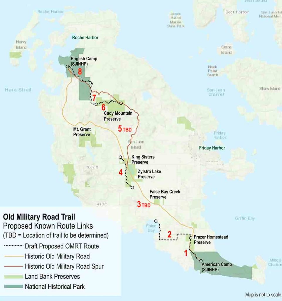
The trail will be opened in phases with eight distinct segments as noted in the map on this page. Segment 1 will run along the existing American Camp Trail from the American Camp Visitor Center to the Frazer Homestead Preserve and is targeted for opening in 2022. This will coincide with the 150th anniversary of Kaiser Wilhelm I’s arbitration decision granting San Juan Island to the United States. Additional segments will follow.
11-minute narrated project summary slideshow:
Video Transcript:
[Download]
FULL TRANSCRIPT: Welcome to an introduction to the Old Military Road Trail on San Juan Island.
The historic military road once connected American Camp and English Camp. Its origins likely began as a game trail, later used by ancient inhabitants of the Island. In the mid 1800’s, the Hudson’s Bay Company – with the assistance of Cowichan and other Indigenous workers – extended the route as a sheep run to prime pasturelands. Finally, during joint military occupation of the 1860’s, English and American forces further extended and refined the route.
Although long ago abandoned and nearly forgotten, the military road has historical significance. Its ancient use allowed early inhabitants passage to the interior of the island to access foraging and hunting grounds. Additionally, it served as “hot-line” between the forces during military occupation. Messages were sent via horseback and, on occasion, the leaders met to discuss local, island issues. Also, the route allowed the troops to gather for celebrations, holidays and recreational activities. It allowed them a chance to get to know each other and likely contributed to peace on the ground. The road developed as multiple tracts and spurs over time to serve a common corridor, providing a route for local trade. And, finally, it supported non-indigenous settlement of the island that followed joint military occupation.
So, why is the time right for a modern version of the military road to reconnect the camps? Well, San Juan Island has beautiful scenery and vistas that not only deserve to be protected, but also celebrated and enjoyed.
Additionally, San Juan Island has some seasonal challenges on our rural roads. During the spring, summer and fall as the island population surges, our roads become congested with recreational users and motorized vehicles. The OMRT is an opportunity to improve safety for non-motorized users as well as motorists be providing an off-road alternative corridor across the island.
Multiple surveys over past decades have indicated that island residents desire hiking trails. This most recent 2018 survey by Confluence Research and Consulting for the local Terrestrial Managers Group, confirms that islanders value trails and an assortment of other recreational opportunities.
The OMRT provides an opportunity for connection—to link trails, parks, and preserves from Cattle Point in the south to Roche Harbor in the north.
Additionally, the OMRT would further SJC’s Parks, Trails, and Natural Areas Plan. Goal #1 of that plan outlined a need for quality trails and parks for a variant of passive and active, non-motorized recreation with a sensitivity to the environment and the rural character of the island.
There is a long history of cooperation on San Juan Island. People of diverse backgrounds coming together to support a common goal. And, as with the focus of Island Recreation, that commonality centers on youth and families.
The OMRT project provides an opportunity to build on what already exists. Over past decades, a broad initiative has been pursued to protect agricultural lands, sensitive areas and scenic vistas. Today, numerous organizations work in concert on conservation and have made many of these lands available for public access. These publicly accessible lands are denoted by a star on this map.
What are the lands options for this commemorative trail? Conserved lands where public access can be accommodated might provide an anchor for the trail. Additionally, lands owned and managed by local businesses may offer opportunities as exemplified by the Roche Harbor watershed property. Individual landowners may also wish to offer trail easements along their property. This participation would be strictly voluntary and accomplished only with close cooperation, guidance from the landowner, and with deep respect for personal property rights. And, finally, where other options are unavailable, select county road rights-of-way may allow final completion of the trail.
If we look at existing lands with public access in the south, the trail from the American Camp Visitor Center to the Frazer Homestead Preserve provides an example. This is also the southern terminus of the ACT that currently connects Friday Harbor to the American Camp section of the National Historical Park.
In the center of the island, the trails of King Sisters Preserve and the Zylstra Lake Preserve may provide additional options for a modern version of the MRT.
Finally, in the north, the trails of Roche Harbor Highlands, Mitchell Hill and English Camp would provide opportunities for multi-use recreation to complete the route.
If we put this all together, a cross-island trail begins to emerge. It is the linking of these existing trails, preserves, and parks that will allow for completion of this legacy trail.
The goals of this community trail are many. Improving safety on our county roads for all users is paramount. This trail provides a new opportunity to connect residents to the land. In our society of increasing convenience, this trail provides options to promote health and well-being through physical exercise. The military history of the improved route offers the possibility to honor military service and reflect on the sacrifices of those in uniform. An opportunity to celebrate peaceful conflict resolution between nations. Highlighting First Nations and ancient peoples culture and stewardship over millennia we be a powerful part of the story. The OMRT offers the chance to establish new wildlife viewing sights, promote conservation and land stewardship. San Juan Island has a unique history. Island agriculture, non-indigenous settlement and historic preservation can be showcased along the trail.
Numerous organizations and businesses have endorsed the concept of the OMRT. The OMRT Committee—a subcommittee of Island Rec—serves similar goals and objectives to support youth and family recreation. The Historical Society Preservation Trust, the Conservation Land Bank, the local NP as well as local business and NGOs recognize the value of the opportunity and have lent their generous support.
These are a few comments from representatives of supporting groups. I will pause briefly to allow time for review.
A common element seems to emerge – that this project will have far reaching impact beyond the physical path and that will endure and pay dividends for generations.
The OMRT Committee was formed in the Spring of 2019 and, despite the recent pandemic, has been working remotely to advance the project. To date, a vision has been established—a recreational trail to reconnect the Camps using existing infrastructure, voluntary easements and perhaps select county road rights-of-way. A website has been created to relay information and engage the public—oldmilitaryroad.org. A brochure and poster have been created as well as this slide presentation. The project was also awarded a technical assistance grand by Rivers, Trails, Conservation Assistance Program of the NPS that has allowed the creation of Communication Plan and Concept Proposal. Additionally, a series of articles on local history and trails have been written and published. And, a goal of completion and opening of segment 1 of the trail in 2022.
It is with your support, and the continued engagement of local organizations, businesses, and residents that will allow this project to come to fruition. A legacy of history and beauty to enjoy today and for generations to come.
Goals:
- To create a safe recreational corridor across San Juan Island for people of all ages–walkers, as well as bicyclists and equestrians on appropriate sections, to enhance health and relieve road congestion.
- To celebrate the extraordinary history and beauty of San Juan Island while promoting a sustainable balance between natural resource use and protection.
- To connect neighborhoods and popular destinations and link our two National Historical Parks.
We want your input.
Below is a brief survey regarding the proposed +/- 20 mile-long Old Military Road Trail that will reconnect American and English Camps on San Juan Island for both recreation and educational uses. This modern interpretation of the Old Military Road will be multi-use where possible, utilizing current trails on conserved lands and new trail segments on public and private land by invitation of the owner.
Your participation will assist in shaping this community trail project. Thank you for your input.
Click the button below to download the
complete 35-page Concept Proposal
© 2022 by Old Military Road Trail Committee | A Committee of San Juan Park and Recreation District ( Island Rec )
Website design by: